In the US, we spent 75 years convincing the public to believe the primary function of a street is to carry vehicles through the city; that what was good for cars was good for America and to allocate space and money to bicycles, transit and just pedestrians was tantamount to attacking our national lifestyle. While that may sound like hyperbole, our streets and roads are currently undergoing substantial redefinition around the country to be less car-centric and instead become dynamic thriving human-centered spaces. While this alone can ignite controversy, assuring that our public corridors continue to support both being and moving, and its many modes at the same time invites a whole new wave of issues. Shifting from the car to answer the vast majority of our urban transportation needs will require that we turn to other modes for traveling distances beyond walking and bicycle range. Our current best candidates for this role, buses, light rail and metros, continue to rank low in public appeal and high in public costs. The transformation our cities need is wanting for modes of transport that can both carry urban capacities and offer a compelling experience - in cost & comfort - to get the public on board. But, as with anything in the public domain, it won’t be easy.
Our city streets are increasingly contested, congested and constantly evolving assets under pressure from changing community priorities to accommodate needs like movement in its many forms, utilities overhead and underfoot, green spaces, human spaces and public services. In her book, Streetfight: Handbook for an Urban Revolution, Janette Sadik-Khan, formerly Commissioner of the New York City Department of Transportation (DOT) rightly characterized the “invisible war” taking place in our city streets today. Her account captures the chaos of sidewalks, bike lanes, and auto lanes all simultaneously being vied for by private automobiles, taxis, ride-shares, buses, trucks, pedestrians, bicycles, scooters and soon autonomous vehicles. While these modes wrestle for space, the street also struggles to accommodate utilities below grade, overhead infrastructure, trees, street furniture, and the property and privacy rights sensitivities of everyone along the way. This pressurized reality is nothing new, but its complexities - spatial, temporal, social and political - continue to intensify with each passing year.
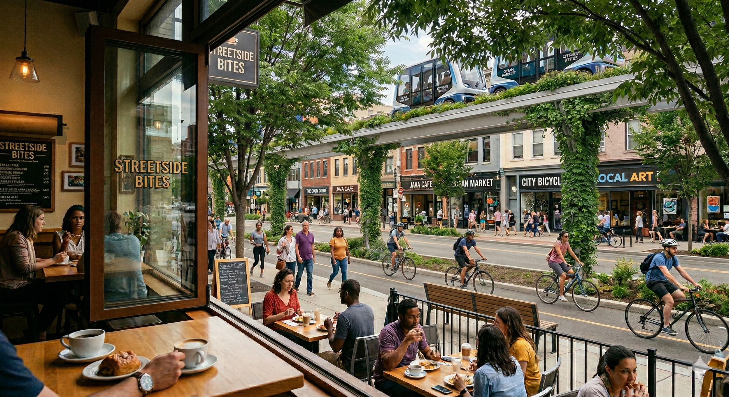
It was into this landscape that my company has been working to introduce a new, permanent, form of mass transportation. Though not necessarily a new idea having first been deployed over 50 years ago in West Virginia, recent advances in autonomous vehicle and fleet control technology is transforming this nearly forgotten concept into a compelling opportunity to significantly improve urban mass transit. Contrast this with the autonomous vehicle technology rolling out into cities in the past year or two that highlights two important realities: 1.) current autonomy can be safe and reliable, and 2.) While reliable in limited scale of operations, its ability to provide mass transit scale service is seriously in doubt. Cities will need both in the mix of choices. PRT provides on-demand service, not fixed schedules; moves significantly more people than street-level autonomous vehicles; and operates autonomously in private, comfortable, electric vehicles at a low cost. Zoox and Waymo have raised our expectations to see these as givens, but the challenge for PRT lies in building the integrated, dedicated infrastructure. High capacities are enabled by operating on an exclusive guideway infrastructure. But being small, agile, and capable of running at grade, elevated, or underground, the system requires far less space than conventional transit and costs much less to build for a comparable level of service.
The sins of urban interventions of the past have the public wary of any changes to this tenuous and imperfect balance of uses and space. Our challenge was to provide the best, most equitable use of the shared finite resource of our urban streets, provide an irresistible service and experience for riders, and to become a welcome addition to the city street. Equity meant serving the needs of all city dwellers at the multiple scales of the place or block, the neighborhood and at the wider city scale. Transit operates in the latter two realms, but impacts all three. We were not alone in trying to enter the market with the promise of solving one of cities’ most vexing problems - affordable, sustainable, appealing mass transit. If merely being better technology isn’t a sufficient proposition to be included, what will earn it an invitation to join in the mix and find a successful place in the city?
Major urban corridors offer the irresistible attribute to anyone trying to address city scale problems and that is CONTINUITY. This is not a new reality. In 19th century Paris, with memories of the French revolution still fresh in people’s minds, Napoleon III faced just such a problem: How could he move his military across the entire city when it was made up an urban fabric riddled with centuries’ of very discontinuous, uncoordinated conditions? He directed his prefect of Seine, Georges-Eugène Haussmann, to come up with a solution. His response was to demolish thousands of buildings and narrow, winding streets of the dense, medieval fabric of the city and carved out long straight swaths of the city for the wide boulevards connecting major civic landmarks, expansive parks lining them with the 7 story boulevard architecture that have come to symbolize the City’s unique urban charm and powerful urban scale order. Wisely, he included the creation of new sewers, lighting, and street trees to the scope. Drastic as they were to accomplish a rare, worst-case solution, these changes provided multiple amenities that Parisians still enjoy on a daily basis like cafes, wide sidewalks for people, planting, long views enhancing orientation and wayfinding. Mayor Hidalgo has continued to flex this muscle in the past decade with the reallocation and greening of urban spaces away from parking, cars and hardscapes to people and green spaces with stunning success gaining praise from around the world.
One hundred years later, New York went through a somewhat similar episode of drastic transformations in the service of wider ‘necessities’, but with less clear success. Robert Moses, wearing a long series of titles during his tenure with the city, set out to ‘modernize’ the city through an ambitious urban renewal program to clear large areas of the city to build new freeways, bridges, tunnels, parks, public housing and numerous civic cultural projects. Unlike Paris’ Haussmann boulevards, Moses’ freeways were single purpose concrete intrusions that permanently displaced wide swathes of the city and divided communities. Even when lined with green spaces to become ‘parkways’ through the suburbs, they could never also serve as parks for people. Aside from direct highway access into the city, they offered little — and in many cases delivered outright harm — to the communities they displaced. They failed to provide the local scale and city scale value combination witnessed in Paris. We set out to deliver value to all three scales: the place, the neighborhood and the city.
Will there ever be room for new solutions? - a New PRT
This challenge defined much of my efforts over the past seven years at work. Like Haussmann's focus on national security and Moses' on urban scale mobility, the system's initial priority was to provide mass transportation that would both draw people away from cars and remain affordable for existing public transit users. Our added challenge was to contribute to the larger campaign to improve streets as shared public spaces. The lessons of Paris, New York and other real world precedents helped us formulate a solution that would succeed at all three scales of the city and the user groups associated with each one.
The primary challenge for this system and continuous infrastructure in general remains, however, is that it must be built using real, physical elements that require some of that precious space. It's one thing to fit the infrastructure's small cross section into a street's wide right-of-way, but it becomes much harder when that diagram is extruded into three dimensions, encountering conflicts and crossings along the route, and even more difficult when adding the necessary vertical support structure at ground level. On open land, at grade, this integration is simple—no conflicts or vertical structure are needed. However, in the dense, complex urban environment, even early subway builders recognized that the surface was too complicated for high-capacity transit, necessitating grade separation. Ground level is the city’s premium real estate and the main stage for this conflict.
As this tension escalates, there is no choice but to go up or down. A genuinely human-centered strategy will prioritize the ground level for people-centric spaces, light mobility modes, green areas, transport access points, and all local activities. As subways and utilities have demonstrated, moving infrastructure up or down is often the only way to avoid conflicts and ensure continuous routing.
Grade separation enables high capacity, but it comes at a significant price. Elevating a system - road, rail or guideway - is always more expensive than running along the ground, like a paved path, roughly 4-6x as expensive. Putting that same system underground will be closer to 8-10x the cost, depending on context. We discovered two critical realities that would shape our route planning and project strategy going forward and seem axiomatic now: 1.) Every dollar for higher cost translates to less line length and less service, and 2.) The infrastructure cost for this system is significantly less than the cost of traditional modes like light rail trains or buses. This means that for a given capital allocation, the PRT solution could provide significantly more system coverage. A secondary plus from the lower capital cost is the prospect of using less money to provide the same service coverage freeing funds for other public needs.
We would also go on to learn a great deal about the cost sensitivities surrounding public infrastructure projects and how they stack up against political sensitivities. In the end, integrating this new, permanent infrastructure into the finite space of urban corridors demonstrated how intensely contested urban corridors have become for all urban interventions. Cities are already very busy places, and as densities increase and users become more diverse in both their mobility and space needs, it will be essential to be more flexible and multi-functional. Everything at ground level must contribute either functionally or aesthetically to the performance of the street, even if the element is holding up the infrastructure running overhead.
Street Users
Over the course of each day, individuals may take on a variety of spatial and functional needs multiple times. From sitting on the sidewalk, to walking a short distance, to taking a longer trip, people will adopt some or all of these modes as they go about their daily lives. As they do, the value they place on a given space will also vary. The challenge for improving the quality of city streets lies in defining whose needs are to be prioritized and when they should be balanced with other potentially conflicting needs. In the past, quick, high capacity connections from the suburbs to the urban core were seen as delivering the lifeblood of an entire metropolitan area - suburban commuters. In practice these priorities drained the inner cities of resources to maintain their infrastructure while paving over the places that made the cities thrive. Enter the downward spiral of degraded urban neighborhoods driving suburban flight and drained municipal tax revenues. For the past twenty years, cities have been returning to the basic question: Who are our streets intended to serve, what functions and spaces do they need and how do these decisions affect the city’s overall success, both socially and economically? If the example provided by former Paris Mayor Anne Hidalgo's top-down prioritization of people places over business and movement is any indication, the cards are being restacked. Once car-choked streets are now teeming with bicycles, pedestrians, trees and greenery that are helping to significantly reduce the city’s unhealthy heat island and poor air quality conditions. Motorways cutting off the city from the river are now promenades filled with thousands of people every day strolling, cycling and enjoying the scenery. The current renaissance in the city is proof that these aggressive human-focused measures are good for the whole city.
The three major groups vying for their needs in the street correspond to the three scales described above: residents/ places, visitors/ the neighborhood and those just passing through from elsewhere in town, the transients. These describe modes of use rather than fixed identities. Individuals can shift from one mode of city-user to another in the course of a day. Also, streets can shapeshift as well, but the underlying physical infrastructure must be built to anticipate these transformations. A resident who cherishes the dynamic streetlife of mixed uses and diverse people out their front door can desire a safe bicycle lane to connect to another neighborhood and hope for ample safe places to park their car or store their bicycle. Or, if they have or rent a car, they might want to get out of town as quickly as possible regardless of what neighborhoods their path takes them through. City streets will rarely serve only one group and therefore must balance these often conflicting functions, but being clear about a street’s primary purpose helps reinforce the legibility of the city, communicating to people “places to be”, “places to move safely” and minimize the spaces impacted by the vehicles and necessary infrastructure of those just passing through. Communities are no longer willing to cede a public street to a single use, let alone a private beneficiary. The fruits of these shared assets must also be shared or justly compensated.
Residents
The first core user group are, of course, residents. They want the street to be a "living room." These are people who live or work in a place. It is their home. They are the neighbors, or, in Jane Jacobs’ words “the eyes on the street”. They have a sense of ownership and prioritize livability, atmosphere, safety and the qualities associated with simply being in a place. They patronize local businesses, attend local schools and hang out in the local parks, streets and visit their neighbors. They are also the businesses themselves. The spaces in front of and around their front doors are critical to their success. Life there is on foot, connections are made by walking.
Visitors
On the other hand, visitors want the street to be a lobby, convenient and inviting for coming and going to and from a place. They need spaces for arriving by a variety of modes of transportation - bus stops, stations, or private modes needing parking spaces and lots for cars, bikes and scooters. Shared modes add to this list of demands as shared micro modes co-opt space between uses inserting themselves painfully into this mix. Travel lanes, sidewalks, bike lanes and auto lanes don’t need to be fast or free of interruptions, but they must connect to parking - spaces or bike racks - close to their destination. They also want to be able to understand the places they pass through, signage, wayfinding and large scale appearances are priorities because they can only be perceived while on the move. Once they arrive, however, they are happy to shift into ‘resident’ mode, even if only for the time of their visit. The needs of moving yield to just being and we shift gears. Different things begin to matter. The quality of the place needs to hold up - safety, interest, activity, atmosphere.
Transients
Lastly, the third group vying for space within the city streets are those folks ‘just passing through’ are the transients operating at the city scale, who pass through like ghosts, barely registering the places they traverse. As commuters they want the street to be like a pipe, non-stop, direct with little value for the qualities of place they may pass through. They prioritize continuity and their value is enjoyed by folks elsewhere - downtown, across town, out of town, etc. just not here. They serve the wider metropolitan population - both urban and suburban but the burden of accommodating their pathways is borne locally. The wide roadways, subways, elevated causeways needed to handle these urban scale capacities require continuous space and so, practically need to be underground, elevated or plowed through the urban fabric. Cities of the twentieth century expanded to include vast suburbs shifting the priorities to overwhelmingly favor this last group with devastating results for local, urban communities. Aside from the high price paid by inner city communities, providing that infrastructure has come at an increasingly hefty price, to the point of grinding the provision of inner urban mass transit transportation to a near halt. Cities can’t build all the transit communities need without help from the federal government. Elevated trains and buses above streets and between buildings has become impossible, both financially and politically. Their physical intrusion carries negative impacts one can not mitigate. Blocked views, threats to privacy, shade and shadow impacts all begin as abstract fears, but quickly become real obstacles to implementation. Underground metros or BRT systems carry such financial impacts that when they can be built, we don’t get much for the effort.
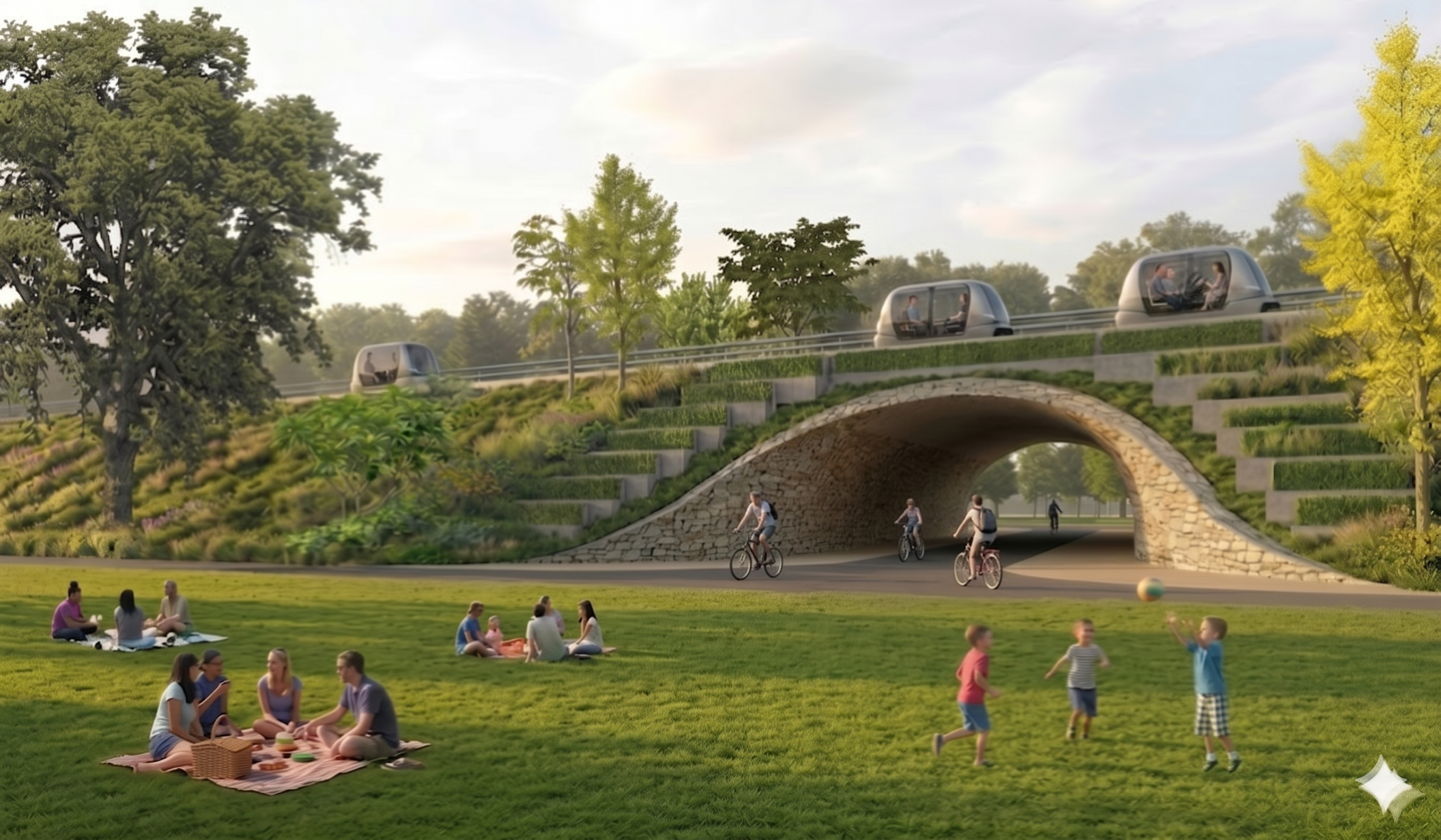
Landscaped raised guideway integrated into the park. Image prompted by author, generated by Gemini Ai
This is the quandary we sought to overcome - providing high capacity connectivity serving the wider city at a lower cost than trains, more convenient than buses while still being a contributing element in this highly contested urban setting, the street at all three scales. PRT’s ability to move lots of people using much less space than those old ‘transient’ modes would surely earn this a place at the spatial negotiating table, we felt. While we chased many opportunities for our system, the conversations requiring alignment in the middle of an existing road or street regularly met with a pause or outright pushback and skepticism. Other locations or alignments steering us clear of city streets encountered much less resistance.
We began engaging airports, campuses, new greenfield developments, etc. where the lines were simpler, stakeholder groups less demanding, less sensitive. I even found less opposition, in fact managing to rally support for the system to run through a public park. Again, the transit+ approach proved critical. Initially the park route would have been a simple pass through “pipe” serving points elsewhere, but not the park itself. I was aware that such a proposal would not be successful, it provided nothing for the park’s users. We added stops within the park to provide direct access, activate the place at both ends and indirectly helped deter a chronic homeless presence that weighed heavily on the wider use of the park by the city residents. We went further to modify the type of elevated structure used to be an earthen berm. This provided a softer, landscaped edge to separate the main open fields from the messy light industrial uses neighboring the park. Openings below the guideway still allowed access to and from the park, but the space now felt ‘contained’ and surrounded by greenery. Presenting this vision to the Park Conservancy leadership, the stewards of the park, we came away with their provisional support. A major project milestone. That it would someday carry thousands of passengers quietly to and through the park was a bonus.
The project is far from completed, but these early adjustments allowed the team to win the trust of a key stakeholder and contract to proceed to the next step. We had overcome a major hurdle no others had managed to overcome. The big takeaway, especially in the US stakeholders rights are powerful, was that the introduction of any new element into the urban environment - city street or public park - must offer something to all three groups or face rejection.
What would make them want us in their community?It came down to a philosophy of winning the support of local communities by asking the question: What enhancements can we add to the PRT infrastructure that would prompt a neighbor who might never ride the system to want one of those in their neighborhood because it makes the whole place better? The answer we learned was to move beyond the notion of single use infrastructure to create a framework for a variety of public functions, spaces and features. The goals shifted from one of mitigating a negative intrusion to one of initiating a positive transformation along the route. I labeled the resulting hybrid of infrastructural functionality with human scaled spaces and functions “Infratecture” capable of serving local residents, neighborhood visitors and cross town travelers wherever it goes.
Infratecture
Expanding upon the infratecture concept, I launched a process to imagine, define and incorporate new complementary functions and elements into our technology’s elevated infrastructure. I began by analyzing the space ‘below the tracks’. History and current urban works provided a long list of examples as inspiration. Rome’s remaining ancient viaducts, marvels of civil engineering and civic city building, still offer a profound sense of place and identity for cities throughout Europe. Since the end of the Roman Empire, in fact, people have inserted additions into these durable structures for new uses for housing, storage, and shops. More recently, artifacts of the industrial revolution have been transformed into powerful, distinct urban elements. In the 1990s, Paris renovated an 18th century elevated rail viaduct into a linear garden on top and shops below called the Promenade Plantée. Other cities in Europe followed and in the US, it inspired New York’s Highline project. These were all successful exercises in adapting major infrastructures either abandoned or obsolete into new, appealing catalysts for healthy urban development. Drawing from these precedents, I pushed the concept of infratecture to propose a program of hybrid multi-use infrastructures embodying many of the best elements of good architecture including human-scale uses, spaces, and locally compatible forms and materials. The ground level remains the domain of people, plants and lighter uses, while overhead the city’s crosstown mobility needs can carry on befitting the twenty-first century.
As with the valuable transit service above, the space below is continuous and can provide rain-protected, illuminated places for bikeways, running paths, trees, planted landscapes, water elements, kiosks, shops, pop-ups, public services and even art installations. Testing these ideas in a variety of climates, I identified how the supporting structure could serve double duty as space defining architecture or a shade protection or carrying cooling misters in hot climates. Providing such multiuse infrastructure carrying this and other citywide services like parcels can flip the historic legacy of such single-use insertions into the city of dividing communities and numbing the areas along them, to become paths of connection, attraction and vitality. Station locations will become a nexus of local activity and the corridor shifts from transient to resident, localized, intensified and enriched. These station areas always hold the promise of energizing neighborhoods.
With this rich set of options and many more potentially around the corner, the question remains: Who’s going to make room for this? In this land of the sacred automobile lanes, these questions would historically be non-starters, but given the continued successes of Paris’ and other cities’ transformations from the reallocation of spaces devoted to cars in favor of multi-use, people spaces continue to be validated in numerous ways. Perhaps the once blasphemous notions of lane diets and expanded cycling, pedestrian and green space will also allow room for new, innovative transit options in our cities’ streets. The exciting opportunity presented by new mass transportation technologies is to leverage their lower costs, and reduced space needs to improve urban mobility while increasing room for enhancements to make our urban corridors desirable spaces unto themselves. The physical aspects of infrastructure, the tectonics, therefore can be seen as a positive creator of new spaces, facilitator of connections, energizer of places if we only shift our thinking and widen our lens.


